Factual record. No finding of causation or responsibility is made here.
The approach
The approach: works, bank and drainage
Dated views of the approach, a closer look at the bank, and the council’s written account. Family photographs from 1 May 2025 were taken seven days after the crash.
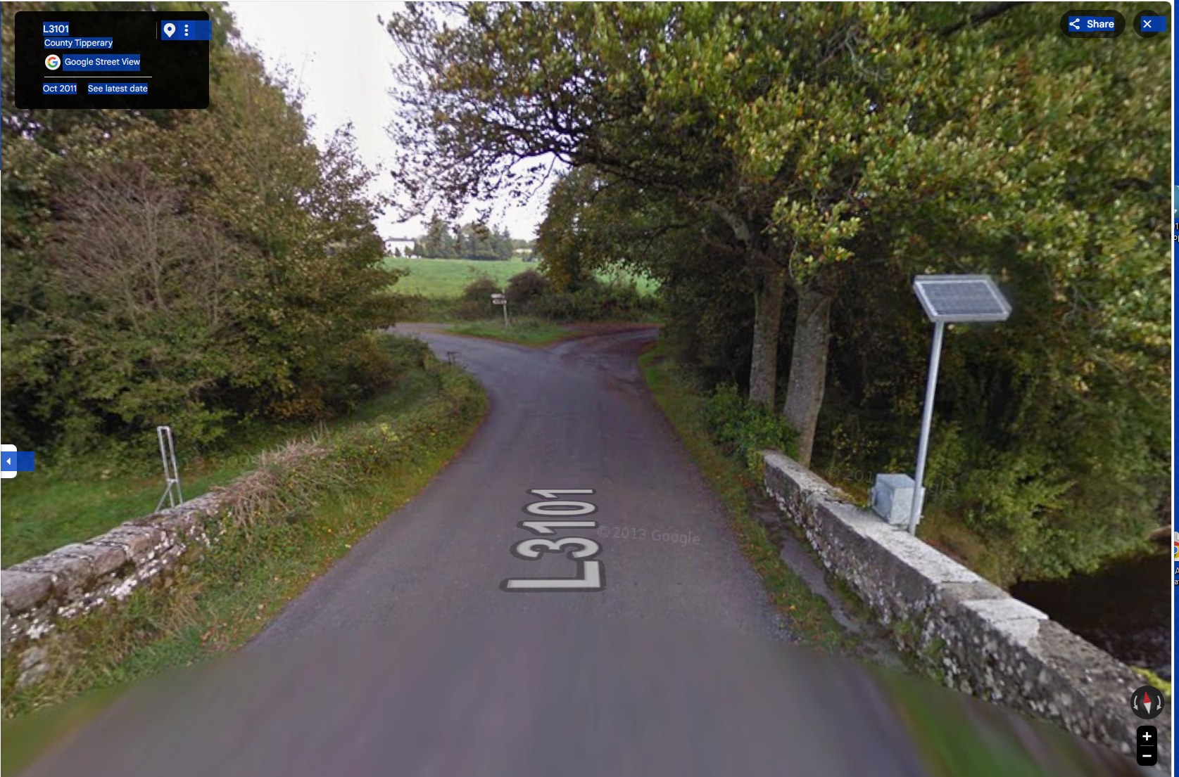
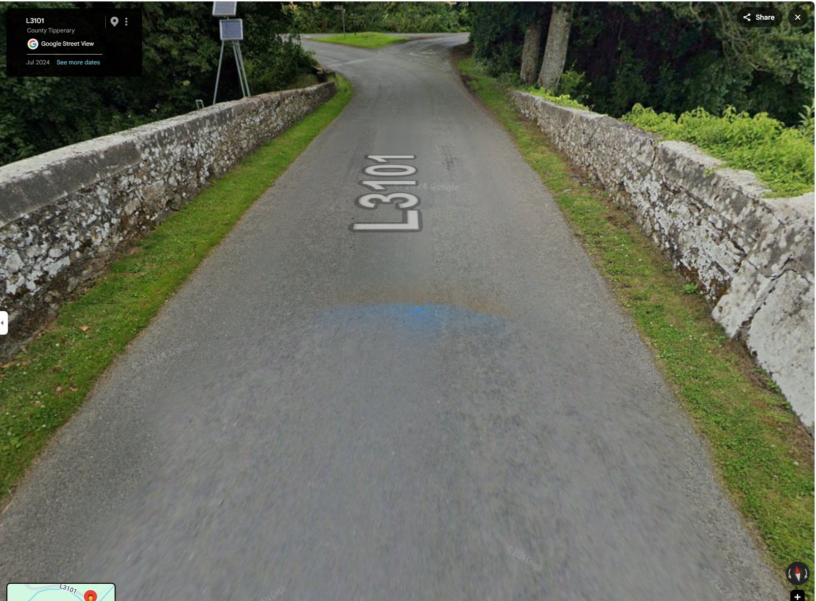
Google Street View imagery of the same crossing, dated October 2011 and July
2024, provides a dated comparison of the visible approach.
October 2011.Google Street View imagery, October 2011.July 2024 — the same view.Google Street View imagery, July 2024.
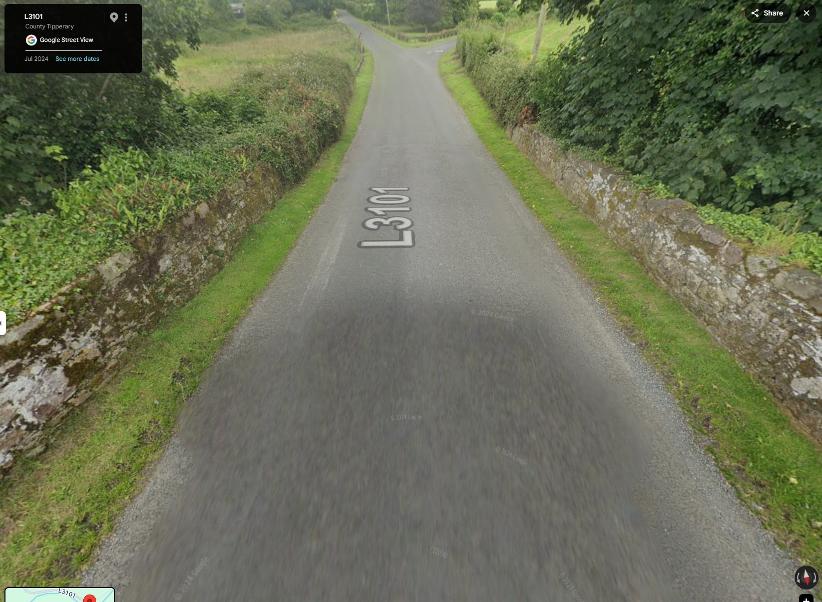
Beyond the bridge, the far side tells its own story: there, both parapet walls stand intact and capped, and the
road continues without the sharp turn a driver meets on the approach where Bronagh’s car left the road.
The far side of the bridge: both parapet walls intact and capped, and no sharp turn. Google Street View imagery, July 2024.
Google Street View imagery of the L3101 crossing at Killardry Bridge, dated October 2011 and July 2024 (Google’s own capture dates). These views do not by themselves establish the dates or scope of council work at this bank.
The bank along the approach — and why it matters
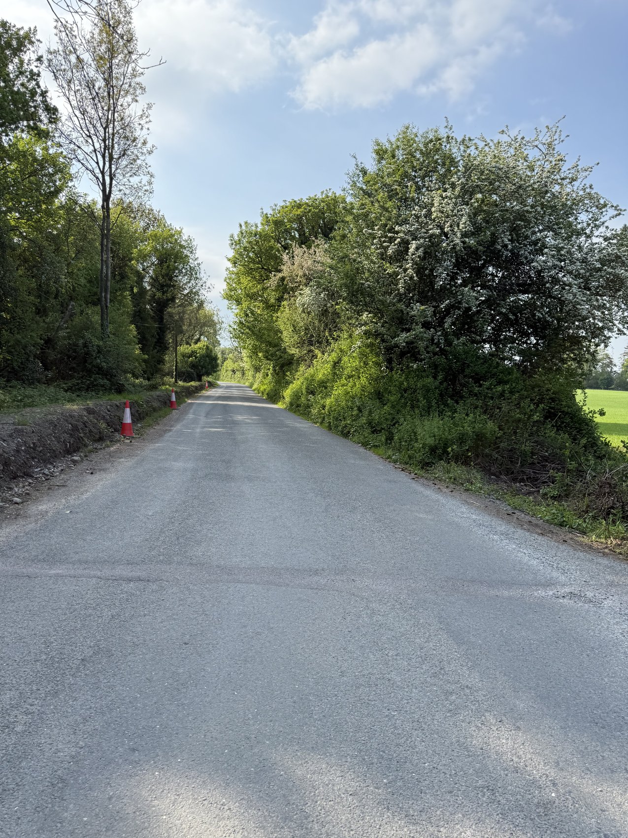
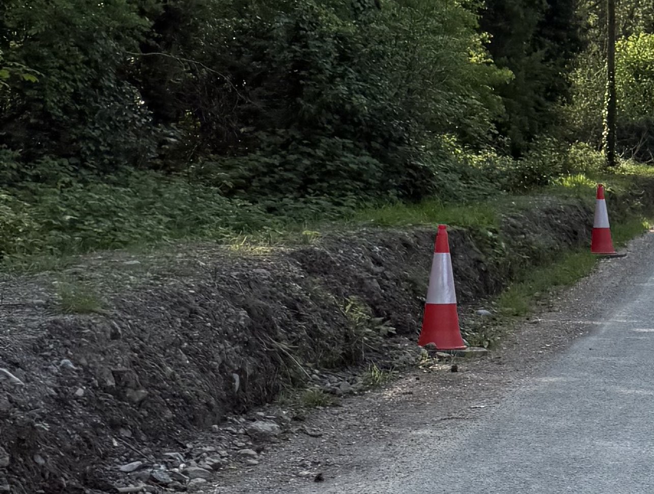
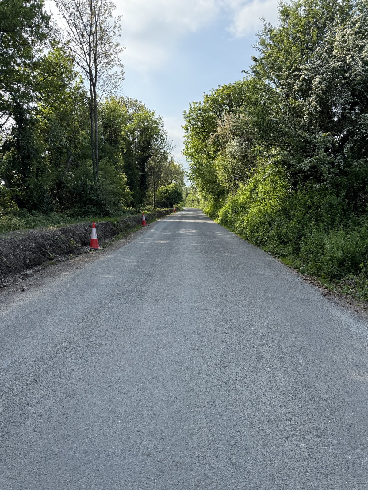
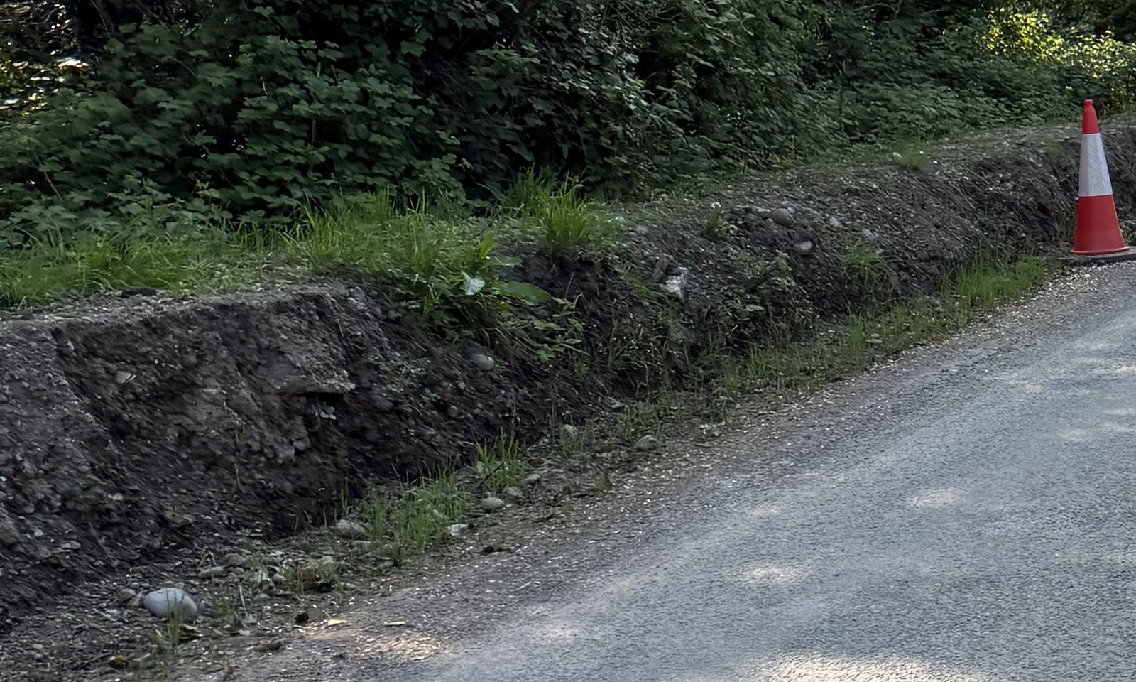
Along the approach to the bridge, the family’s 1 May 2025 photographs show a raised roadside earth verge between the carriageway and the ditch. They were taken after the crash and are GPS-tagged at the site.
The long approach: a raised roadside earth verge is visible along the road edge. The family raises a concern about water leaving the road in heavy rain. Family photograph, 1 May 2025.Detail of the exposed soil face of the raised roadside verge. Family photograph, 1 May 2025.The raised roadside verge along the approach, with traffic cones visible during the post-crash road closure. Family photograph, 1 May 2025.Detail of exposed soil and loose material on the roadside verge. Family photograph, 1 May 2025.
The family asks where surface water from the approach was intended to discharge, and whether the road edge was protected in rain. The council’s Internal Review Decision says its drainage activity was cleaning roadside-verge inlets and that no specific drainage works were carried out on the bridge itself. The statement distinguishes the bridge from the approach and does not settle those questions. Dated work orders, drainage design, discharge details, inspections and traffic-management records would assist.
Family photographs, 1 May 2025, GPS-tagged at the bridge approach and taken after the crash. Council account: Internal Review Decision, 18 February 2026 — see /documents/internal-review-decision-2026-02-18/. The photographs do not establish the crash-night surface, the date of any works or drainage function. These questions are being pursued through the proper legal process.
The council’s location-specific account
In its Internal Review Decision, Tipperary County Council says the only drainage works on the L-3151 were roadside-verge inlet cleaning, that there were no specific drainage works on the bridge itself, and that the 2025 L-3151 works were northwest of the bridge location. The decision does not identify specific works at this bridge approach. Dated work orders, drainage drawings and inspections, and site-safety and traffic-management records would still be needed to establish the date and scope of any work at this bank. Read the related public council record.
Tipperary County Council, Decision on Internal Review, 18 February 2026 (FOI 174/25), quoted and linked above.
Capping gone. The Council's inspection recorded it, 93 days before Bronagh died.
21 January 2025: Tipperary County Council's engineering inspection rated Killardry Bridge "Significant Damage", capping "partly removed", signage "No". Bronagh died at the bridge on 24 April 2025.
Council engineering inspection, 21 January 2025 · Family photograph
1 of 11
The grass verge, grown level with the lowered wall.
The family's view: where the verge has grown level with the lowered wall, it forms a ramp onto it. The record does not establish who formed the verge, or when.
Family photograph, February 2026
1 of 11
The drainage pipe at the bank.
The Council's review says the only drainage work on this road was cleaning the verge inlets. The family's timeline puts this pipe about ten days before the collision; its view: it cannot drain the road.
Family photograph, 1 May 2025 · Council internal-review decision, 18 February 2026
1 of 11
Clay and stones from the open bank, on the tarmac.
Photographed 1 May 2025, a week after Bronagh died. The bank was left open; wet material from it is sitting on the road surface where cars pass.
Family photograph, 1 May 2025
1 of 11
An open channel beside the bend.
An open channel along the roadside at the bend, photographed 1 May 2025. The family's view: it was left open with no barrier or warning sign. The photograph does not show when it was dug.
Family photograph, 1 May 2025
1 of 11
The long open bank on the approach, the night it rained.
24 April 2025: Toureen's rainfall day recorded 21.5 mm (including hours after the collision). The family's view: this open earth bank, on the right driving to the bridge, destroys the road beside it in rain.
Met Éireann, Toureen, rainfall day 24 April 2025 · Family photograph
1 of 11
Facing the bridge: the approach meets it at 90 degrees.
The Council's 2014 inspection records the approach skew at 90 degrees and a 4.8-metre carriageway; its January 2025 bridge inspection recorded signage "No". The turn she had to make is ahead.
Eirspan principal inspection, 4 March 2014 · Council engineering inspection, 21 January 2025 · Family photograph
1 of 11
Imagine this road at night, in heavy rain.
The family's view: in the dark and heavy rain there were no warning signs, clay and stones on the road, and a broken bridge wall. Unmanaged Council roadworks made a dangerous road far worse.
1 of 11
Councillor Máirín McGrath seconded the motion against a universal 60 km/h limit.
14 October 2024: Motion 2861 asked that the new 60 km/h rural default "not be universal across this County, but apply only in areas deemed necessary by this Council". Council engineers found no road they could recommend to stay at 80 km/h.
Full Council minutes, 14 October 2024, pp. 12–15
1 of 11
James Swords is the Council's District Engineer for this district.
The family asks him and the Council: who managed the roadworks at Killardry, who received the January 2025 inspection, and why were there no warning signs?
District Engineer: Cahir–Cashel Municipal District minutes, 26 May 2025 and 25 May 2026
1 of 11
The record is kept here.
Each photograph and document on these sites carries its source. Factual record. No finding of causation or responsibility is made here.
Road Death Tipp Road Death Tipp Tipperary road deaths — remembrance and records Remembrance and the official records, county by year. Working annual total. Not a count of points on the map. Open the map Partial map coverage. No ages shown. Explore → Partial map coverage. No ages shown.
Cahir–Cashel road statistics Cahir–Cashel Deadly place to drive ↗ × Cahir–Cashel road statistics Road statistics · sourced comparison Cahir–Cashel: 3.03× the national road-death rate 1 January 2018–31 December 2023 (six complete calendar years) . In the full Tipperary–Cahir–Cashel Municipal District, including its rural areas, the derived annualized rate was 8.61 people killed per 100,000 residents , compared with 2.84 nationally . This is an area comparison relative to population, not a personal likelihood. This page uses the full municipal district, not the populations of Cahir and Cashel towns. The linked road-deaths map and record has broader coverage and a different purpose. The headline figures 23 people killed in 21 fatal-collision records in the district 8.61 annualized people killed per 100,000 residents 3.03× the State rate on this population basis 36.5% of County Tipperary’s deaths and 26.5% of its population; the district rate was 37.6% above the county rate. District results The district’s fixed Census 2022 population is 44,532 . The 23 people comprised 11 drivers, 5 passengers, 5 pedestrians, 2 motorcyclists . They were not all drivers. Annual district deaths were 6, 4, 1, 3, 3, 6 from 2018 to 2023. Scroll horizontally to read this table. Five Tipperary municipal districts District 2022 population Fatal-collision records People killed People killed per 100,000 per year Clonmel 25,003 10 13 8.67 Tipperary–Cahir–Cashel 44,532 21 23 8.61 Carrick-on-Suir 20,191 7 7 5.78 Nenagh 40,879 11 12 4.89 Thurles 37,290 8 8 3.58 Scroll horizontally to read this table. Annual people killed Year Tipperary–Cahir–Cashel County Tipperary State 2018 6 10 134 2019 4 13 140 2020 1 7 141 2021 3 10 132 2022 3 7 152 2023 6 16 179 County comparison National baseline: the Republic of Ireland recorded 878 people killed across a fixed Census 2022 population of 5,149,139 , an annualized rate of 2.84 per 100,000 residents over these six years. Tipperary recorded 63 people killed , a rate of 6.25 , ranking #2 of 26 counties behind Monaghan (6.38). Tipperary’s rate was 2.20 times the national rate. Scroll horizontally to read this table. All 26 counties, ranked by annualized rate; the CSO county aggregate does not supply mapped source-record counts Rank County 2022 population People killed Fatal-collision records People killed per 100,000 per year 1 Monaghan 65,288 25 — 6.38 2 Tipperary 167,895 63 — 6.25 3 Donegal 167,084 53 — 5.29 4 Roscommon 70,259 22 — 5.22 5 Louth 139,703 41 — 4.89 6 Cavan 81,704 23 — 4.69 7 Mayo 137,970 38 — 4.59 8 Offaly 83,150 22 — 4.41 9 Kerry 156,458 41 — 4.37 10 Kilkenny 104,160 27 — 4.32 11 Leitrim 35,199 9 — 4.26 12 Longford 46,751 11 — 3.92 13 Westmeath 96,221 22 — 3.81 14 Clare 127,938 29 — 3.78 15 Meath 220,826 49 — 3.70 16 Sligo 70,198 15 — 3.56 17 Limerick 209,536 44 — 3.50 18 Wexford 163,919 34 — 3.46 19 Galway 277,737 49 — 2.94 20 Carlow 61,968 9 — 2.42 21 Cork 584,156 83 — 2.37 22 Laois 91,877 12 — 2.18 23 Waterford 127,363 15 — 1.96 24 Wicklow 155,851 18 — 1.92 25 Kildare 247,774 25 — 1.68 26 Dublin 1,458,154 99 — 1.13 A higher district comparator Boyle Municipal District, County Roscommon, recorded 15 people killed in 14 source records from a population of 24,421: 10.24 per 100,000 , about 19% higher than Tipperary–Cahir–Cashel. This is not a claim that Boyle is Ireland’s worst district; 11 districts were screened in this targeted comparison. Clonmel’s 8.67 rate is marginally higher than Cahir–Cashel’s 8.61; the largest raw count is not the highest district rate. Public council minutes: 2024–2026 These later public records are separate from the 2018–2023 statistical comparison. They record requests, responses and planned work—not findings of causation or proof that work was completed. 2025-05-26 James Swords: recorded response to a safety request The minutes record Councillor John O’Heney asking for safety measures following a recent tragic incident. James Swords is listed as District Engineer present; the response is attributed to that role. Limit: The minute does not name the bridge or specify a parapet repair. It does not say that Gardaí were to design or direct a bridge repair. there is an ongoing Gardai investigation into the incident and if there are any recommendations from the report it will be implemented. Excerpt from the minutes, not a verbatim speech transcript. Official minutes — attendance and District Engineer, PDF p. 1 — Officials Present; James Swords, District Engineer Official minutes — District Engineer’s report, PDF p. 5 — Item 3.4, District Engineer’s Report Official minutes — recorded response, PDF p. 6 — Item 3.4, District Engineer’s Report 2024-10-14 Máirín McGrath seconded the default-speed-limit motion Motion 2861 was proposed by Cllr Niall Dennehy and seconded by Cllr Máirín McGrath, a Cahir LEA member. The full County Council recorded unanimous agreement. The motion sought selective application of the new default limits, rather than universal application across the county. Limit: This was not a motion introducing a blanket 80-to-60 reduction. The December clarification below records the legal-advice referral. Official October minutes — Motion 2861, PDF p. 12 — Item 8.2, Notice of Motion Ref. 2861 Official October minutes — unanimous outcome, PDF p. 15 — Notice of Motion Ref. 2861 outcome Official Council AGM minutes — elected-area roles, PDF p. 2 — Item 2.1, elected members by electoral area 2024-12-09 Council clarification and legal advice The minutes record Chief Executive Sinéad Carr acknowledging support for Motion 2861, while explaining that legal advice was being sought on whether a plenary motion could supersede national legislation. The October minutes were to be amended to reflect that clarification. Limit: This does not establish a road-specific exception or a suspension of national rules. Official December minutes — clarification, PDF p. 2 — Item 3.1, Matters Arising on October minutes 2025-01-13 80-to-60 implementation and weather-delayed signs The minutes record 7 February 2025 as the commencement date for the rural-local-road default reduction from 80 to 60 km/h. They also record severe weather delaying sign-installation work and distinguish a later, wider Phase 2 review. Limit: This is a dated implementation note, not proof of the limit or weather at any individual crash site. Official January minutes — Speed Limit Review, PDF p. 11 — Item 7.1, Roads, Transportation, Health & Safety 2026-05-25 477 district bridges; 14 applications; three funded The District Engineer reported €1 million in county bridge funding, 477 bridges in the district, applications for 14 bridges requiring work and funding for three. Limit: The minute does not establish whether Killardry was among the 14; funding is not proof of completed work. Official May 2026 minutes — bridge funding, PDF p. 6 — Item 3.6, District Engineer’s Report 2026-05-25 Temporary measures considered at Rehill Bridge Following Cllr Máirín McGrath’s request for urgent rehabilitation, the District Engineer reported that Rehill tender documents were nearly complete and temporary measures were being considered to reopen the bridge, with completion hoped for by the end of that week. Limit: This records a plan and expectation, not verified completion. Official May 2026 minutes — Rehill Bridge, PDF p. 6 — Item 3.6, District Engineer’s Report The earlier bridge inspection The family’s published summary of Council inspection record TY-L3151-B-010 reports “Significant Damage” on 21 January 2025 and records downstream capping as “partly removed”. That inspection predates both the 24 April 2025 collision and the 26 May 2025 meeting response. Limit: This is a summary of a Council record held on file, not the original report online. The records checked do not establish whether or when James Swords personally received or read the inspection report. Published family summary of the Council inspection record When was the inspection circulated to the district engineering team, and what action was recorded? Further accountability research Read the full sourced record on the primary statistics page . Representatives Engineering Payments Road budgets Crash coverage Weather Surfaces and works Exposure comparisons Method and limits People killed ÷ fixed 2022 population ÷ 6 years × 100,000. Populations are fixed Census 2022 references. Counts concern collision locations, not resident addresses; the result is not a rate per journey or vehicle-kilometre. Current 2024 reference boundaries are applied retrospectively. The series is provisional and subject to revision. The figures do not establish why crashes happened or measure road-maintenance spending. Return home · Open the broader road-deaths map and record Sources RSA SourceData — Map of Collisions source data — Fatal-collision source records, 2018–2023; mapped locations assigned to current reference districts. CSO ROA15 — Persons Killed and Injured — State and county people-killed totals, 2018–2023; provisional/revisable series. CSO ROA12 — All road users — Independent national cross-check of people-killed totals, 2018–2023. CSO Census 2022 Table 8.1 background notes — State and county 2022 population background. CSO FY108 — official statutory LEA population CSV — 2022 population basis and statutory LEA/district mapping. Tipperary County Council Adopted Budget 2024, Table 7 (PDF) — Five municipal-district populations labelled as based on Census 2022; physical page 20. Tailte Éireann 2024 statutory boundary dataset service — Checked 2024 Tailte Éireann statutory municipal-district boundary dataset service; current reference boundaries applied retrospectively. Irish Statute Book S.I. 631/2018 — Optional Boyle municipal-district/LEA mapping context. Download the five-district CSV · Download the 26-county CSV · Download the public JSON snapshot Factual record. No finding of causation or responsibility is made here.
Contact the family
If you have information about this road, this bridge, or the records on this site, you can write to Bronagh's family here.